
 Sign In
 Create Account


- Owner: POTKC (View all images and albums)
- Uploaded: Dec 05 2018 12:07 PM
- Views: 1,598
- Album Kingdom of Dhahran
© POTKC 2018, reproduction or use not permitted without written and explicit consent

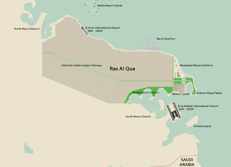
After 1979, a major city planning project in Ras Al Qua was undertaken at the direction of King Khaleel bin Samir al Amin, who took over the throne from his father at the beginning of the year. This expansion brought the city boundaries over 30 kilometers west, out past Al Amin International Airport. The city was planned out in a regular grid, with Halim bin Sultan al Ajam Parkway running through the middle - named after the Foreign Minister who negotiated the country’s independence. Part of the historic center, near the Royal Palace, was left preserved. In an attempt to define Dhahran as a nation not centered only around oil, the Wahah Resort District was included as part of the city plan. Ras Al Qua Port was also built as part of this project.
Apart from the filling in of the city grid as planned out in 1979, no major changes were carried out in the following twenty years. In the year 1999, after the death of King Khaleel, the throne was taken over by King Fathi bin Khaleel al Amin. King Fathi began the Dhahran 2020 program. This was meant to orient the Kingdom of Dhahran away from oil, better taking advantage of its beautiful beaches to develop a tourism industry, and invest more in finance and real estate. As part of Dhahran 2020, the planned-out grid to the north of the historic center and Palace was cleared, making way for the newly-established Mustaqbal Mushriq District, which has (by 2018) already undergone some new construction, and is projected to be filled by malls and skyscrapers by 2025. The project also saw the establishment of the North and South Resort Districts, and the creation of Al Fanta Island, an entertainment island similar to Sentosa in Singapore. The Nafsia Resort Islands - a complex of around 25 artificial islands connected by thin land-bridges hosting Maldives-like island resorts, was created between 2000 and 2005. The entire complex is only accessible by ferry, speedboat, or seaplane.
Finally, King Khaleel International Airport (QUA - ODDR), named after King Fathi’s late father, began construction in 2000, on partially reclaimed land south of the city. QUA Stage One consisted of a single runway and part of the massive modern terminal, and was completed by 2003, when the airport first opened. By 2010, QUA Stage Two - adding the second runway, the rest of the terminal, and surrounding infrastructure - was complete. QUA Stage Three, which could potentially add a third runway and a second terminal at the north side of the airport, has not yet begun.
As part of King Fathi’s Dhahran 2020 program, Royal Dhahrani Airways began a rebranding and modernization to help with efforts to attract tourists to the country. It underwent a significant fleet renewal, retiring many older types, while placing orders for more modern aircraft, and rebranded completely, changing its name to simply Dhahrani.
Disclaimer: This project is designed to look at the progression of aviation in a more-or-less generic fictional Middle Eastern state. Any similarities to real people, locations, or situations may be intentional. I have zero knowledge of Arabic, so while I have spent considerable time trying to get it right, mistakes are possible, and any advice is greatly appreciated.


Well, isn’t that a grid?
It sure is!

This is super duper neat!!!
This is super duper neat!!!
Thanks!

Very late, I know, but I want to commented how amazing this whole project is. You've really outdone yourself with this!
Also, I reckon Al Fatta Island would be the perfect spotting location...

